We often hear the saying that water is life. Although people can live without food for dozens of days, they cannot survive without water for more than three. When we turn on the tap, most of us don’t fully appreciate the value that water represents, where it comes from, the network it flows through and the quality assurance processes that keep it safe. We definitely get annoyed when the water supply is interrupted temporarily, or its pressure falls or its quality declines. While we waste our water resources by leaving the tap open, taking long showers and washing our clothes every day, over 2 billion people living in 43 countries experience high water stress, which means that they have no or little access to clean, safe and quality potable water. By 2025, half of the world’s population will suffer from water deficit, and by 2050 some 5.7 billion people will be living in potential water scarce areas at least one month per year. Today, nearly one sixth of the world population does not have the potable water we drink, one third cannot afford to use water for their household needs, more than 1 billion people use less than six liters of water per day and another 4 million people die each year from water-related diseases. These figures are indeed dumbfounding. And they are also concerning for our region, considering how the issues of water scarcity and water security will potentially compound the already-complex problems facing the South Caucasus.
The dramatic increase of the world population, further expansion of industrialization and irrigated agriculture, rapid urbanization, improved living standards and mass consumption paradigms require more and more water resources, putting immense pressure on the global hydro ecosystem. The situation is aggravated by continuing climate change and environmental degradation, water misuse, increased water pollution and greenhouse gases.
Meanwhile, global freshwater resources remain limited. Figure 1 indicates that only about 2.5% of global water resources is fresh water. However, most of it is trapped in ice caps, glaciers and groundwater, whereas the most accessible and cheapest sources coming from lakes, swamps and rivers account for only about 0.3% of Earth’s total freshwater reserves.
Today, we use 30% more freshwater than the planet is able to produce. Over the past 100 years, the world population increased by three times and global consumption of water increased by seven times; since the beginning of the 20th century, global water consumption has been growing twice as fast as the world population.
According to experts, at this pace, 2030 might be the point of no return for the water crisis. By 2050, we may run out of about 75% of global freshwater resources.
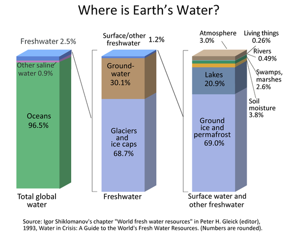
Figure 1
Unequal Geographical Distribution of Water
The water security of a country or a region can come under various types of threats, such as biohazards, climate change, natural disasters, political violence and radiation. However, as was mentioned earlier, water scarcity is the most common threat to water security. Water scarcity itself can be physical and economic. According to Figure 2, about one fifth of the world population in regions such as the Middle East, North Africa, India, Central Asia, Northern China, Northern Mexico and Southeastern Australia face severe physical water scarcity.
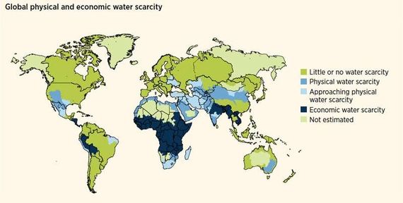
Figure 2
In 1929, colonial Britain signed an agreement with Egypt granting Cairo the right to veto projects higher up the Nile that would affect its watershare. In 1959, Egypt and Sudan signed the Agreement for the Full Utilization of the Nile Waters, granting 55.5 cubic kilometers to Egypt, 18.5 cubic kilometers to Sudan and 10 cubic kilometers for evaporation. Ethiopia was not consulted, though it is the source of the Blue Nile tributary. In 1970, Egypt finished building the massive High Aswan Dam. Egypt’s 55.5 billion cubic meters/year was adequate for Egypt’s 1959 population of 24 million. However, with the current population of over 100 million, Egypt is facing an annual water deficit of around 7 billion cubic meters. According to experts, by 2025 Egypt will possess only about half the per capita water availability that it had in 1990. Moreover, taking into account that the Nile makes up about 90% of Egypt’s freshwater supply and about 85-95% of the total water consumption in Egypt accounts for irrigation, the dam will provoke further desertification of agricultural lands in addition to gradual increases in temperature and evaporation rates that can potentially result in famine.
The Ethiopian stance is different: it is more focused on fixing historical injustice. They refer to their rights over the Nile’s water due to its geographic location. Indeed, the Ethiopian Highlands provide 86% of the Nile’s flow, with 70% of that flow coming from the Blue Nile. Meanwhile, Ethiopia is counting on the cheap energy the dam will provide to satisfy the energy and water needs of its own growing population and industries. Roughly 65% of the country is not connected to the power grid. This project will double Ethiopia’s energy output and will make it a net energy exporter.
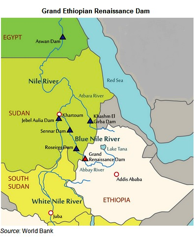
Figure 3
Back then, Libya used to get most of its water supply through desalination plants located in the coastal areas of the country. However, they were very expensive and the volumes were not sufficient to irrigate land for agricultural purposes. Besides, the aquifers of the coastal areas were too contaminated and saline. So, in 1983, an unprecedented engineering project known as the Great Man-Made River Project was initiated to transfer water from desert aquifers to the coastal region of Libya. The project aimed to supply 6.5 million cubic meters of water a day through 4,000 km of pipelines from 1,100 wells via five reservoirs, at an estimated cost of $25 billion. Even at that eye-popping price tag, the cost of this non-renewable water is approximately one tenth of the cost of desalinated water. Through this project, the Libyan government wanted to make Libya water secure for the next century, turning the country into a flourishing garden often referred to as the 8th Wonder of the World. In just six months, agricultural farmland doubled, almost entirely eradicating hunger in the country.
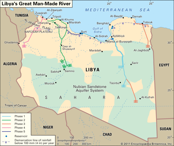
Figure 4
Example of Potential Conflict by Large Powers: The Tibetan Plateau
China has built over 87,000 dams on its rivers, collectively generating about 352 GW of electricity, more than Brazil, Canada and the U.S. combined. For 70 years, China has been building dams on its internal rivers, which has led to the displacement of over 23 million people. However, over the last 40 years, it has increased its hydro power energy capacity by 20 times. Nowadays, after imprisoning its own internal rivers with dams, China has turned its eyes toward building new dams on major international rivers that have their sources in Tibet.
Nearly half of the world population depends on the water tower of Asia: the Tibetan rivers. As China exercises dominant control of these water resources, it is able to dictate its terms to downstream countries using water as a geopolitical tool to impact their foreign policies. The Tibetan Plateau is the source of water for a dozen transnational rivers, including the Yangtze, Yellow, Indus, Ganges, Brahmaputra, Irrawaddy, Salween and Mekong rivers. Most of the freshwater of Pakistan, India, Bangladesh, Nepal, Bhutan, Myanmar, Thailand, Cambodia, Laos and Vietnam takes its origins from the Tibetan glaciers. Therefore, minor changes in water flow could provoke a chain of environmental refugees in the most densely-populated countries of the world. This makes Tibet China’s most important geographic asset.
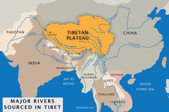
Figure 5
However, Iraq, the furthest country downstream, was hit the worst. The country is running out of water. It does not control the flows of its rivers, nor does it have the necessary infrastructure to clean the existing water resources. The two biblical rivers are indeed the source of life for Iraq. Around 71% of Iraq’s overall water comes from Turkey, another 10% coming from Syria and Iran. Iran alone has built nearly 600 dams within the last 30 years and dozens of new dams are in the planning stage. Thus, all three countries are holding the two rivers and their tributaries hostage, which today allows for only 25% of the Euphrates’ normal flow to reach Iraq. Along the way, these rivers provide Iraqis with potable and irrigation water, and with electricity. About 80% of Iraq’s water goes to agriculture, which provides a livelihood to more than a third of its 38 million people. By 2035, Iraq will have lost 11 billion cubic meters of water with an annual demand of 71 billion. Some 650 villages already went dry in 2018. All this put massive pressure on Iraq’s infrastructure to clean and distribute the water. However, much of its infrastructure has been destroyed during the three devastating wars Iraq had to go through since the early 1990s.
These examples of regional water conflicts are just a drop in the bucket of the huge list of water clashes that took place previously, are taking place now, or can potentially occur in the future. Other examples include the water tensions between Israel and Arabs in the Jordan River conflict, between India and Pakistan over the Indus River, the Central Asian countries located upstream and downstream of the Amu Darya and Syr Darya Rivers, the Guarani Aquifer countries, and many more.
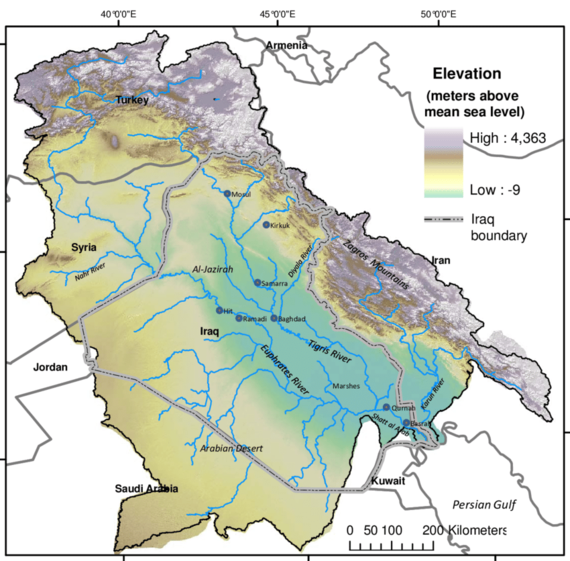
Figure 6
Wealthy North America: Potential Problems between the US, Canada and Mexico
Water conflicts don’t spare rich countries. There exists a conviction that the more developed countries of Europe, North America and Russia will not face serious threats to their water security due to large possessions of water resources, appropriate infrastructure, populations’ better alignment to the existing resources and good relations across borders. However, this idea of relatively healthy water relations between developed nations compared to those in most other parts of the world is being challenged, turning more vulnerable and less predictable.
For instance, even though the U.S. and Canada are strategic allies, enjoy good relations and signed the Boundary Waters Treaty in 1909, the water issue has climbed to the top of the agenda in U.S.-Canada relations. Both Canada and the U.S. possess roughly similar reserves of renewable freshwater resources, but the U.S. has nearly nine times more people than Canada. In 20 years, the U.S. is going to need $384 billion of additional funding to ensure its own population with drinkable water. Climate experts believe that unprecedented climate change will cause significant negative outcomes for the Great Lakes basin, diminishing its water resources.
The same goes for U.S.-Mexico water relations. In 1944, an international pact signed between the U.S. and Mexico defined the sharing and distribution of water resources between the countries. According to the treaty, Mexico receives about four times more water than it provides to the United States. However, Mexico is obliged to deliver water to the States, releasing the dam waters into rivers nourishing the Rio Grande that flows through much of the U.S.-Mexico border. It comprises the vital irrigation sources for southern Texas farmers cultivating vegetables, sugar cane and other crops. But since then, the needs of both societies have changed and the availability of water has exponentially decreased. As a result, in 2020, Mexican farmers and activists from the region of Chihuahua seized the Boquilla Dam on the Conchos River that is a major tributary of the Rio Grande, proceeding to burn cars and governmental buildings. They even held a group of local politicians hostage in order to halt the delivery of the dam’s water, as their own lands were at risk due to severe droughts.
Climate Change and “Water Migration”: A Hypothetical Trajectory
It is obvious that climate change is one of the major factors of increasing water insecurity and stress, and thus an important source of all these conflicts. The Earth’s hydrological cycles are changing, increasing weather unpredictability. Increasing temperatures increases evaporation and precipitation, causing frequent droughts and floods, soil degradation, desertification, sea-level rise and coastal erosion, storms and cyclones, and melting glaciers. This all affects the availability of safe drinkable water and forces people to displace. Many countries are already facing hunger, illness, poverty and economic crises because of the water deficit.
According to experts, by 2050, about 300 million people will become “climate migrants,” the vast majority of which will be caused by water scarcity and an inability to continue socio-economic activities. Will the world economy be able to sustain the forced and climate-induced migration of this many people? There were already up to 50 million “environmental refugees” registered by 2010, and the 10 largest displacements of people in 2016 were climate-related.
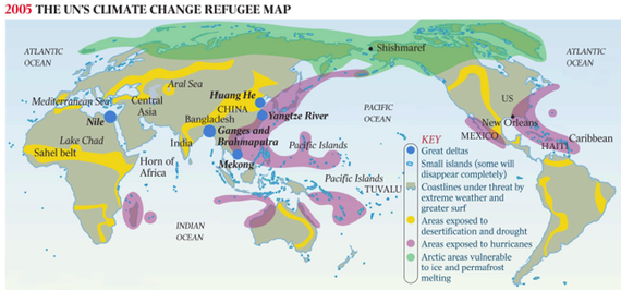
Figure 7
If the local migrants from affected zones move to the big cities within their own countries, then the regional migrants will be moving toward the North and South, far from the tropics to temperate areas. Thus, the hypothetical projective model in Figure 8 shows that there will be about a dozen major migration routes. For instance, the majority of migrants from the Caribbean, Central America and northern South America will be migrating north to the United States. North Africans will be fleeing north to Europe. Southeast Asians will be heading north to China, Korea, Japan and Russia. Malaysians and Indonesians will be seeking access to Australia, while the populations of Central Asia and the South Caucasus will very likely seek migration toward Russia.
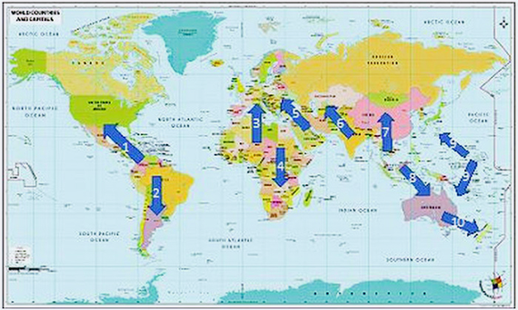
Figure 8
The rivers get their water from underground sources, snow melts and rain. Therefore, their yearly volumes are unpredictable and changing. To overcome the issue related to seasonal fluctuations of river flows, about 80 reservoirs with a total capacity of 1.4 billion cubic meters have been built in Armenia to regulate the flow of mountain rivers, to accumulate meltwater and rainwater for irrigation, to meet energy needs, and to mitigate climate change. Thus, 70 reservoirs are used for irrigation, six are intended for hydropower generation, and only three are dual purpose, i.e. for irrigation and domestic water supply. Before the collapse of the Soviet Union, many canals, 403 pumping stations, and 2,221 deep and artesian wells were built and operated in Armenia.
Armenia is also rich with its artesian water basins. Its groundwater reserves are estimated at just over 4 billion cubic meters and are disproportionately distributed. About 70% flows to the Ararat Valley, whose water resources are at a depth of 40-300 m. Groundwater in Armenia is of great importance for water balance. 96% of drinking water comes from groundwater, as it tends to have high quality indicators and is less costly. About 3 billion cubic meters of groundwater is used annually, of which 1.6 billion meters are from springs and 1.4 billion cubic meters from rivers and lakes. It is one of the few countries where most of the community lands are irrigated by groundwater.
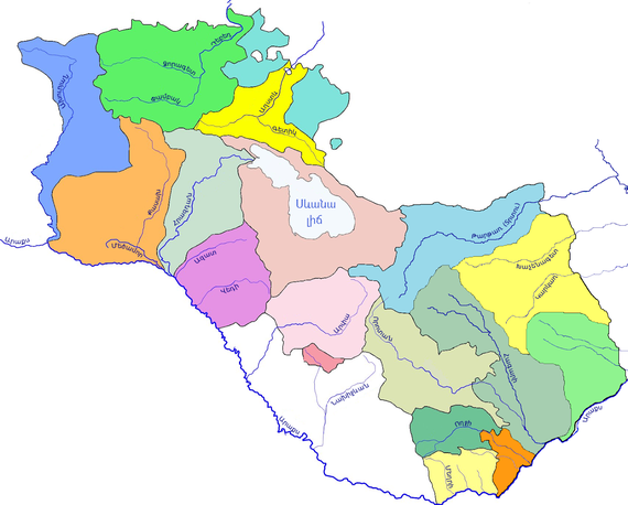
Figure 9
However, the largest source of surface water resource is Lake Sevan, which has a volume of about 33 billion cubic meters composing about 80% of Armenia’s water resources. Its fresh water plays an important role for Armenia’s water security landscape.
The 2020 Artsakh War and Water Consequences
Unfortunately, as a result of the 2020 Artsakh War, the Karvachar region of Artsakh came under the control of Azerbaijan. Karvachar does not only have crucial military-strategic significance for the entire region due to being the highest and most invulnerable part of Karabakh, but also plays a key role in the context of water security. Karvachar includes the catchment basins of the two main rivers feeding Lake Sevan, Arpa and Vorotan, along with the Terter and Khachen rivers that provide nearly 85% of the yearly average water supply of Karabakh. Therefore, the largest share of water resources in the former Nagorno-Karabakh Autonomous Oblast (NKAO) originates from outside of its administrative borders. Before the war, Nagorno-Karabakh was in a position to almost entirely secure its environmental security and water resources. After the war, the region as well as the entire Armenian water security architecture came under new security realities of extreme vulnerability and threat.
Today, more than ever, water security should comprise one of the most important components of Armenia’s national security. Several important reservoirs fell under Azerbaijani control after the war, including the Mataghis Reservoir, with its 5 million cubic meters of water, and Varanda 1, Varanda 2 and Varanda 3 reservoirs, with 10 million cubic meters of capacity. Overall, 22 out of 24 reservoirs came under Azerbaijani control, although the biggest one in Artsakh, the Sarsang Reservoir, with its 565 million cubic meters of water, was saved from occupation.
Azerbaijan is facing severe water shortage, nearly 90% of its water resources come from outside its borders. The rivers entering Azerbaijan originate mainly in Turkey, passing through Georgia, Iran and Armenia, making the problem of water security more difficult, increasing its dependency on its neighboring countries. Thus, Azerbaijan is planning to build several dams in the newly-occupied territories.
The Turkish Problem
Considering Armenia’s diplomatic relations with Turkey, it is no surprise that relations pertaining to water issues remain quite problematic. Currently, Turkey has about 870 dams or 2.1% of the world’s dams. Since its population will be reaching 100 million by 2030, Turkey wants to achieve energy sufficiency and security by building another 800 dams. Therefore, Turkey has a very aggressive political agenda over water in the region, sitting on the taps of the biggest water resources and defining the water shares for its neighbors. In 2019, Turkey claimed the construction of dams and roads as its top economic development priority. It is estimated that water consumption will reach 100 billion cubic meters in Turkey by 2023.
Armenia’s concerns revolve around Turkey’s self-serving use of the Araks River and its Akhurian tributary. Araks traces its origins to the Armenian Highlands, about 200 kilometers away from the Armenian border with Turkey, and flows over 1,072 kilometers, crossing four countries: Turkey, Armenia, Iran and Azerbaijan. It annually takes about 2.5 billion cubic meters of water to the Caspian Sea. Before entering Armenia, there are four dams on the river, giving the Turkish side control over 54% or 1.4 billion cubic meters of Araks water resources. Turkey is further planning on building new dams, the biggest of which will have 1.3 billion cubic meters of storage capacity, thus holding 70% of Araks water in Turkey. Armenia, in its current state, is already facing a shortage in filling its reservoirs, as the Araks enters Armenia with 60% diminished water compared to previous decades.
Regarding the Akhurian reservoir, it is the biggest in Armenia with a volume of 525 million cubic meters, built in 1980 and agreed to common use with Turkey on a 50/50 basis by the Kars agreements signed between Turkey and the Soviet Union. However, Turkey is breaking those agreements and is not freeing 250 million cubic meters of water toward the dam, by building new dams in upper streams of the river. This directly affects the Shirak, Aragatsotn and Ararat regions of Armenia, leaving many communities with shortages in irrigation water. From 128 villages of the Shirak region, only 35 receive centralized water supply, while 20 villages have no water at all, forcing farmers to rely on underground water or bring it in by other means.
Climate Change, Water Infrastructure and Water Theft
All of the above is aggravated by other factors such as climate change, poor water infrastructure and water theft. Climate change is a major factor affecting countries’ water securities all over the world, and Armenia is not an exception. For instance, if current trends continue, by 2040, the annual average temperature will increase by 1.7-1.8 °C. By 2100, it could increase by 4.5-4.7 °C, which will decrease the influx of water into Lake Sevan by 19%. The consequences, needless to say, will be dire.
Meanwhile, because of poor and old water infrastructure, damaged reservoirs, broken pipelines, and irrigation network malfunction, yearly losses average about 70% of Armenia’s water resources (officially though, water leakages are less than 45%). In 2019, overall consumption was 2.1 billion cubic meters, whereas the remaining 5 billion flowed to the Caspian Sea. About 50% of Armenia’s 444,000 hectares of arable land is not used for its intended purpose. Instead, we are witnessing the salinization of lands and scenes of gradual desertification. Today, the de facto yearly average water resources per capita in Armenia is not 3,100 cubic meters as it needs to be, but rather 465 cubic meters, less than in Turkey, Georgia, Azerbaijan and even Iran.
Additionally, hundreds of fish farms mainly use the groundwater of the Ararat Valley, as well as hundreds of small hydropower plants built throughout the country that place additional pressure on Armenia’s hydrosystem. Moreover, many of those farms and plants operate illegally, are constructed with flawed technical and geographical methods, and have served only as a source of income for those associated with the political elite.
Measures to Take
1. First and foremost, the Armenian government should officially declare the water security issue a top priority in its national security strategy and foreign policy agendas.
2. An officially mandated advisory body must be formed, comprised of domestic, diasporan and international experts, with the task of developing strategic policies and long-term solutions.
3. The Government must develop plans for the construction of new water reservoirs. It has been publicized that Armenia is planning to construct 22 new reservoirs, with an overall 139 million cubic meters of additional water capacity that will cost an estimated $220 million over the next 15 years. Urgent attention must be given to the reservoirs of Vedi, Kaps and Yeghvard, with the objective of completing these projects within the next couple of years.
4. Nationalize the country’s water system, from water production, distribution, to water treatment systems. Since water security is an inherent part of national security, the ability of the state to control this exceedingly crucial resource is fundamental to the overall security of the nation. As such, the monetary interests of international corporations must be deprioritized in favor of national security matters that are specific to Armenia’s water security.
5. Form well-equipped and technically-trained special mobile units that will conduct constant and continuous monitoring of Armenia’s strategic water resources, including but not limited to critical water infrastructure, dams, pipelines and treatment plants. These security mechanisms are crucial, considering the high risk of biological and chemical threats to Armenia’s hydrosystem from neighboring Azerbaijan.
6. Develop and implement a nationwide public educational initiative on water consumption. The percentage of wasted water in Armenia is critically high, while irresponsible usage may be mitigated to limit such waste.
7. Armenia must invest and develop transnational water pipelines to partake in the multi-trillion water industry. By investing in water technologies, along with pertinent water pipelines to Iran and the broader Middle East, Armenia may partake in the commoditization of water, but in a responsible way, thus mitigating the pressure that is placed on the country’s hydro-ecosystem.

